
 Prince William County Road Closure App
Submitted by Prince William County Government
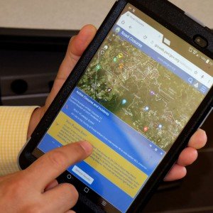
Getting information about road closures in Prince William County just got easier with the launching of a new smartphone, tablet and/or computer app.
The county's Geographic Information System, or GIS division, worked with the Public Safety Communications Center to create an online application so that people can see road closures in the county in real time. The application shows current incidents, as well as planned road closures.
The application shows current incidents, as well as planned road closures.
In addition to the map, the application also includes a feature where the user can sign up to receive notifications about road closures via text or email through the Prince William Community Alert Network, or PWCAN.
Kevin Sadrak, a county GIS developer, explained that the map updates every 30 seconds with current inputs from the county's fire and rescue and police departments.
"It'll take any sort of incident that comes into the system, translate it to the map and send out notification by text or email and show it on the map," Sadrak said. "Whenever something shows up, the system sees it and fires off the notifications."
It also includes information from VDOT regarding their incidents and planned road closures in the county.
For those who sign up to receive road closure notifications, the new application also gives an all-clear signal when things get back to normal, Sadrak said. "You will actually get a notification that the road has been reopened."
Visit www.pwcgov.org/roadclosures to see the map and sign up to receive notifications.


Support Bristow Beat - Donate Today!