
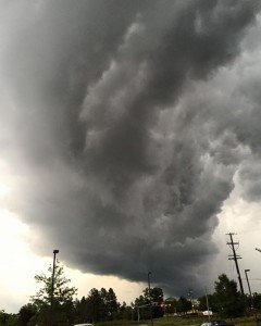
 "Shelf Cloud" Photo by Gainesville resident Scott Murphy, June 2015.
 The D.C and Northern Virginia areas are under “Tornado Watch, “Sunday, April 14 from 6 p.m. until Monday, April 15 at 3 a.m., according to the National Weather Service.
The hazardous weather outlook is in effect for the entire Washington, D.C. and Baltimore regions.
“Two rounds of showers and scattered thunderstorms are expected this evening and overnight," said the NWS. "The main severe weather threats are damaging wind gusts and an isolated tornado. Heavy rain in thunderstorms may lead to isolated instances of flooding."
Strong winds with isolated wind damage are also possible on Monday with gusts up to 50 miles per hour.
Virginia counties affected by the Watch include - but are not limited to - Prince William, Fauquier, Fairfax, Culpeper, Loudoun, Stafford, Madison, Rappahannock and Shenandoah.
Cities include Manassas, Manassas Park, Fairfax, Falls Church, Alexandria, Fredericksburg, Winchester, Harrisonburg and Charlottesville.
In cases of flooding roads, slow down and turn around and try to avoid affected areas.


Support Bristow Beat - Donate Today!