
 Updated: 9 p.m., Jan. 12
The National Weather Service forecasts persistent snowfall overnight and through Sunday afternoon.
"The heaviest snowfall expected later overnight through Sunday morning," a NWS forecaster said.
Additional snowfall of several inches is expected during this period.
"Temperatures will remain at or below freezing through the night into Sunday as some places won't even make it above freezing until Monday afternoon," they said. "Obviously, these temperatures will support snow accumulations and sticking to all surfaces."
Original Story:
Initially the National Weather Service forecast 2-4 inches of snowfall in the region; however, the discussion suggests that residents may see more.
" I am concerned that east-west oriented banding may cause locally higher amounts across these areas," a NWS forecaster said. "The guidance continues to trend heavier, so it is quite possible an additional upgrade of headlines and forecast totals could be in the offing."
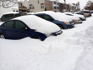
An alert sent by Prince William County warns that residents could see 8-12" by the conclusion of the storm.
PWC is under a Winter Storm Warning; travel conditions are expected to deteriorate this afternoon. The National Weather Service has increased their forecast for PWC to 8-12” of snow, beginning Saturday afternoon. Please stay off the roads after dark Saturday and plan to avoid travel Sunday. Updates will be posted to the County’s emergency information page at https://emergency.pwcgov.org.
However, forecasters are stopping short of calling for a foot of snow.
"There is still uncertainty regarding the placement and location of any banding precipitation and also with the track of the low pressure system."
NWS issued a Winter Weather Advisory for the area Friday for Saturday at 4 p.m. through Sunday at 6 p.m.
BristowBeat.com will continue to monitor weather conditions throughout the storm.


Support Bristow Beat - Donate Today!