
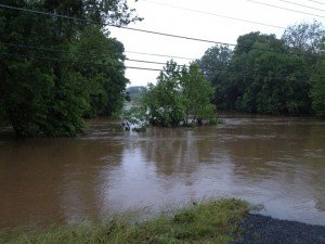
 Photo of Broad Run flooded along Linton Hall Road and Sudley Manor Drive during a previous storm.
Updated: 12:30 p.m.
National Weather Service has upgraded the Flash Flood Watch to a Warning for the area until 2 p.m. Thursday.
"At 12:28 p,m, reporting gauges indicated streams were near their peak levels and starting to recede, NWS said. "As a result, ongoing flooding issues should end early this afternoon."
Additional rain is possible in this area later in the afternoon or evening, and with elevated streams, more flooding is possible later.
Original Story:
The National Weather Service has issued a Flash Flood Watch for the area until 7 p.m. Thursday.
According to the NWS, the potential for torrential rainfall exists throughout the day.
"The first area of rainfall is ongoing with additional thunderstorms expected later this morning into the afternoon and early evening," they said. "Rainfall rates of 1 to 3 inches are expected in the strongest storms."
A reported 3 inches of rain has fallen overnight in Gainesville.
In addition to road closures on the western end of the county, southeastern Prince William County was under a Flood Warning, this morning. That warning has been extended to northern Prince William, the City of Manassas, City of Manassas Park and central Fairfax County.
A Flood Warning exists in southeastern Prince William County and Stafford County.
There is also the potential for flooding of small streams as well as poor drainage areas; mudslides could occur in steep terrains.
NWS forecasts a chance of showers and thunderstorms, mainly before 2 p.m. Friday with a high near 87 degrees. The chance of precipitation is 50 percent.
Bristow Beat will continue to monitor this weather event and provide updates.


Support Bristow Beat - Donate Today!