Jason Shaw
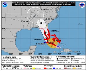
The National Weather Service expects Hurricane Irma to weaken as it moves north. Image Courtesy of NWS
The
National Weather Service says it expects Hurricane Irma to weaken as it tracks north next week; however, it could still bring some severe weather to the area. "There is still a threat for enhanced impact from Irma but that is less likely as of now since guidance continues to shift farther off to our south and west with the track," NWS said. As the monster storm moves into Florida Saturday, its remnants will arrive in Northern Virginia midweek. Most likely the area will see soaking rain Tuesday into Wednesday and minor tidal flooding. "Irma is most likely to weaken over the Tennessee Valley Tuesday through Wednesday, but moisture in a southwest flow aloft is likely to move into the area increasing the chances for rain," a NWS forecaster said. "There is still a threat for heavier rain that can lead to flooding along with isolated tornadoes and gusty winds should Irma track farther north and east toward the Midwest instead of the Tennessee Valley, which is still in 'the cone of uncertainty' early morning." The storm will continue to affect residents through Thursday. As a precaution, Virginia Governor Terry McAuliffe has declared
a state of emergency ahead of the storm. "It is unfortunate that just as our nation has begun the process to repair the catastrophic damage from Hurricane Harvey, that we are faced with another extreme storm,” Governor McAuliffe said. “However, if there is one lesson we can take from the tragic events that occurred in Texas, it is that we must redouble our preparation efforts. The order I issued today is intended to both protect our commonwealth and to make sure we have every option at our disposal to help our neighboring states when Irma makes landfall.” This action will allow the commonwealth to mobilize resources, such as the Virginia National Guard, if needed. The Governor advises residents to make preparations including securing flood insurance and assemble emergency kits that contain food, water, medications, pet supplies and important documents in case of an evacuation. If forced to evacuate, residents can lookup their evacuation zone
here. As Irma moves from Florida northwestward towards Georgia/Tennessee Monday night, NWS forecasts that the area will see increasing high clouds and chances for rain. Highs Monday will be in the low to mid 70s, with lows Monday night in the 50s.
Bristow Beat will continue to monitor the storm.


