
 Image Courtesy of the National Weather Service
The area is currently under a Blizzard Warning.
"A Blizzard Warning means severe winter weather conditions are expected or occurring," NWS said. "Falling and blowing snow with strong winds and poor visibilities are likely; this will lead to whiteout conditions, making travel extremely dangerous."
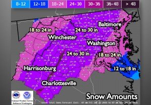
NWS reports snow will move from the southwest in the morning, over the DC metro area between 3 p.m. and 5 p.m. and over all of Maryland by 7 p.m..
"Conditions are expected to deteriorate Friday afternoon with the heaviest snow, strongest winds and potential life threatening conditions expected Friday night through Saturday," a NWS forecaster said.
Winds will be north 25 to 35 mph with gusts up to 55 mph, blowing and drifting of snow is expected.
 Image Courtesy of the National Weather Service
Temperature will be in the upper 20s throughout the storm.
NWS warns dangerous traveling conditions are expected; visibility will be reduced to near zero at times in whiteout conditions.
"Do not travel. If you must travel; have a winter survival kit with you. If you get stranded, stay with your vehicle. Prepare for the possibility of power outages during snowy and cold conditions."
Bristow Beat will continue to update information about the storm.


Support Bristow Beat - Donate Today!