
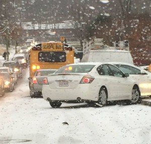
 The National Weather Service has issued a Winter Storm Watch from late Tuesday night through Wednesday evening. Forecasters are calling for 4 or more inches of wet, heavy snow, with some area seeing higher accumulations. Rain and snow totals were increased as models have trended wet and colder; temperatures through the period will remain below normal. This winter weather event comes in the form of two low pressure systems, which will bring mainly rain and some sleet to the area Tuesday and snow early Wednesday.
 "There should still be a lull in precipitation late Tuesday afternoon into Tuesday evening but with some uncertainties as to how long in time and coverage," NWS said. "Once the lull is over, precipitation will start up again sometime Tuesday afternoon and should be in the form of mainly snow; some sleet may mix in at times."
Thursday will be partly sunny, with a high near 44 degrees.
"The second low will pull away from the coast on Wednesday, bringing an end to precipitation by the evening,"a forecaster said. "A high pressure system will be in control of our forecast area Thursday into Friday night allowing for dry conditions over most of our region."
Forecasters are watching another system, which could affect the start of Prince William County Schools spring break.
"A boundary and low pressure system may affect us during the weekend bringing additional snow or rain to the area but there is still uncertainty on track and timing," they said.
Stay with Bristow Beat for more on the storm.


Support Bristow Beat - Donate Today!