
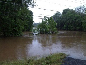
 Photo of Broad Run flooded along Linton Hall Road and Sudley Manor Drive during a storm in 2013.
Updated: July 28, 8 p.m.
The National Weather Service has cancelled the Severe Thunderstorm Watch as of 8 p.m.
Original Story:
The National Weather Service is warning residents of some severe weather that may impact the coverage area beginning Thursday afternoon.
According to the NWS, a Severe Thunderstorm Watch is in effect until 12 a.m., with damaging winds as the primary threat.
"An area of low pressure is expected to develop tonight over southern Virginia and track northeast Friday," a forecaster said. "Several rounds of showers and thunderstorms are developing this afternoon and will continue into Friday morning,"
The weather service even warned of the possibility of an isolated tornado.
The NWS also issued a Flash Flood Watch until 11 a.m. Friday.
"Given ample moisture and instability, showers and thunderstorms will be capable of producing torrential downpours with rainfall rates of an inch or two per hour at times," "a forecaster said.
Heavy rainfall in short periods of time could cause rapid rises on creeks and streams and flash flooding are possible.
Chances of heavy showers and thundershowers continue throughout the weekend.


Support Bristow Beat - Donate Today!